Weather Lookup

Current Conditions — KFLO

75°F Mostly Clear
💧 Humidity 100%
💨 Wind 6 mph WSW
👁 Visibility 9.0 mi
🌡 Pressure 29.67 inHg

Hourly Forecast — Florence,SC

3:00 AM 77°F Partly Cloudy 💨 6 mph W
4:00 AM 76°F Mostly Clear 💨 5 mph W
5:00 AM 76°F Mostly Clear 💨 5 mph W
6:00 AM 75°F Sunny 💨 5 mph NW
7:00 AM 75°F Sunny 💨 5 mph NW
8:00 AM 76°F Sunny 💨 5 mph NW
9:00 AM 80°F Sunny 💨 6 mph NW
10:00 AM 82°F Sunny 💨 6 mph N
11:00 AM 84°F Mostly Sunny 💨 6 mph N
12:00 PM 87°F Sunny 💨 6 mph NW
1:00 PM 88°F Mostly Sunny 💨 6 mph NW
2:00 PM 90°F Sunny 💨 6 mph NW
3:00 PM 91°F Sunny 💨 6 mph NW
4:00 PM 91°F Sunny 💨 6 mph NW
5:00 PM 91°F Sunny 💨 5 mph NW
6:00 PM 90°F Mostly Clear 💨 5 mph NW
7:00 PM 87°F Mostly Clear 💨 3 mph NW
8:00 PM 84°F Clear 💨 2 mph N
9:00 PM 81°F Mostly Clear 💨 2 mph N
10:00 PM 79°F Mostly Clear 💨 2 mph N
11:00 PM 78°F Mostly Clear 💨 2 mph N
12:00 AM 77°F Mostly Clear 💨 2 mph N
1:00 AM 76°F Mostly Clear 💨 3 mph N
2:00 AM 75°F Mostly Clear 💨 5 mph N

Daily Forecast — Florence,SC

Overnight 75°F Mostly Clear 💨 6 mph W
Wednesday 91°F Sunny 💨 6 mph NW
Wednesday Night 70°F Mostly Clear 💨 2 to 6 mph N
Thursday 89°F Sunny 💨 6 mph N
Thursday Night 69°F Clear 💨 0 to 5 mph N
Friday 92°F Sunny 💨 2 mph NE
Friday Night 73°F Mostly Clear 💨 3 mph S
Saturday 92°F Mostly Sunny then Slight Chance Showers And Thunderstorms 💨 1 to 8 mph SE
Saturday Night 74°F Slight Chance Showers And Thunderstorms then Partly Cloudy 💨 2 to 8 mph SE
Sunday 91°F Showers And Thunderstorms Likely 💨 2 to 8 mph S
Sunday Night 73°F Showers And Thunderstorms Likely then Chance Showers And Thunderstorms 💨 3 to 7 mph S
Monday 89°F Showers And Thunderstorms Likely 💨 3 to 8 mph S
Monday Night 74°F Showers And Thunderstorms Likely then Chance Showers And Thunderstorms 💨 2 to 6 mph S
Tuesday 90°F Slight Chance Rain Showers then Chance Showers And Thunderstorms 💨 2 to 6 mph SW

🚗 Road Conditions

Good

Nearest monitored road: East Cheves Street (Secondary)

3:30 AM Good
3:45 AM Good
4:00 AM Good
4:15 AM Good
4:30 AM Good
4:45 AM Good
5:00 AM Good
6:00 AM Good

Forecast Discussion — ILM

View Full Discussion on NOAA →

What Has Changed

Only minor changes for the new forecast period. Coastal flood advisory issued for downtown CAPE fear tonight.

Key Messages

1) cooler and drier conditions will be in place the next few days followed by increasing chances for rain later in the coming weekend into next week.

Discussion

Key message 1...cooler and drier conditions will be in place the next few days followed by increasing chances for rain later in the coming weekend into next week.

Key message 1 description...the dynamic system bringing showers and thunderstorms to the region is slowly making its way south with a pre frontal trough currently moving southward. The actual front is a little behind just making its way through the western part of the state. Convection...non severe still wants to develop east west along the trough while drifting southward. Pops will take time to clear the region now shifting more toward 9-12 UTC. A cooler and drier airmass settles over the region through saturday with highs in and around 90 and lows even dipping into the upper 60S in places. The warmer readings will be friday and saturday although still no threats to heat related headlines. By the end of the upcoming weekend and certainly into next week mid level troughing perhaps a closed low returns to the southeast with good rain chances/moisture advection returning to our area.

Aviation — 06Z Wednesday Through Sunday

Mainly VFR conditions expected through the period outside of some lingering convection slowly drifting southward across the area currently. Citing the tenacity of the convection applied tempo groups along coastal sites while inland terminals should be all but clear of convection.

Extended forecast...VFR conditions should dominate wednesday night through saturday. Flight restrictions possible sun from convection associated with a frontal boundary snaking back northward.

Marine

Today through saturday...continued to advertise the small craft advisory through the early morning hours although conditions are marginal. For the remainder of the forecast expect a rare northwest flow today across most of the waters with speeds of 10-15 knots with a few higher gusts. Being almost august this flow will not last long and a southerly component to the winds quickly returns to the region tonight through the weekend. Regarding seas outside of the 3-5 ft range perhaps an isolated six feet reading for the next few hours the range dips to 2-4 feet with more like 2-3 feet as the forecast period progresses.

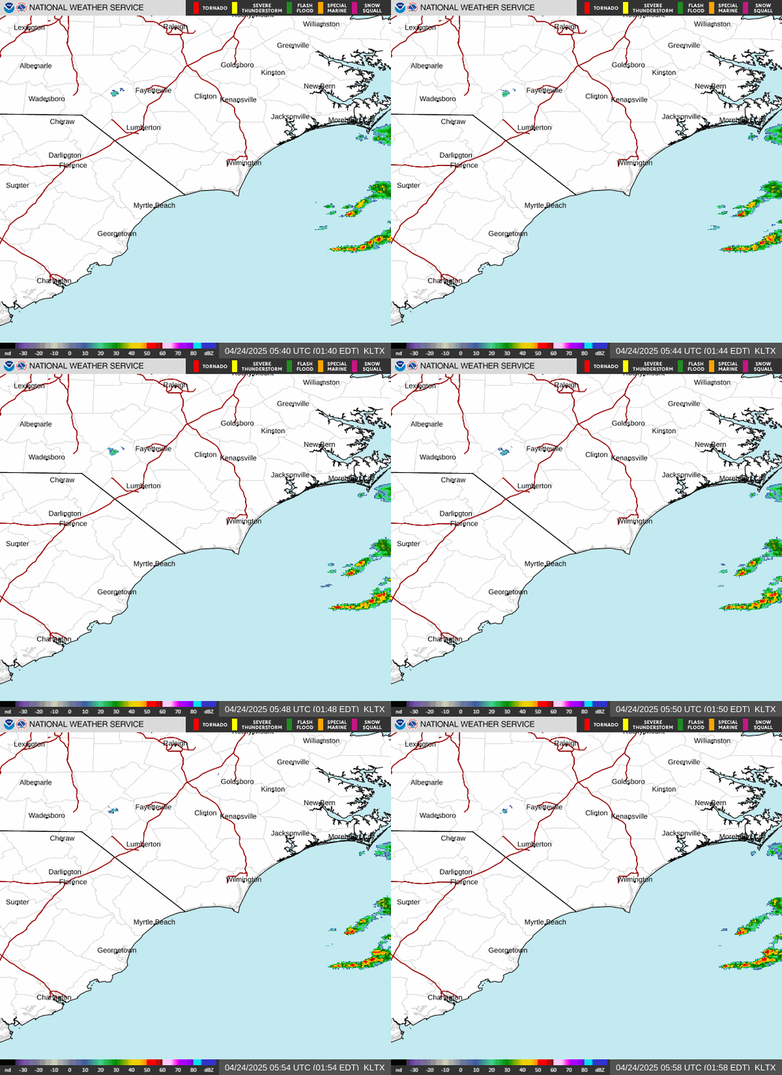
Radar — KLTX

Radar loop for KLTX

Surface Analysis — Eastern U.S. (South)
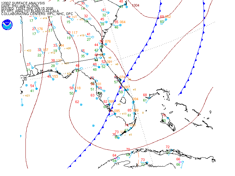
Surface map for Eastern U.S. (South)

Satellite

Satellite imagery
Expanded view