Weather Lookup

Current Conditions — KGCC

79°F Clear
💧 Humidity 45%
💨 Wind None mph None
💨 Gusts 26 mph
👁 Visibility 10.0 mi
🌡 Pressure 30.0 inHg

Hourly Forecast — Gillette,WY

11:00 PM 75°F Partly Cloudy 💨 13 mph SE
12:00 AM 74°F Partly Cloudy 💨 13 mph SE
1:00 AM 73°F Partly Cloudy 💨 13 mph SE
2:00 AM 71°F Partly Cloudy 💨 12 mph S
3:00 AM 69°F Mostly Clear 💨 10 mph S
4:00 AM 68°F Mostly Clear 💨 10 mph S
5:00 AM 67°F Mostly Clear 💨 10 mph S
6:00 AM 65°F Sunny 💨 10 mph S
7:00 AM 69°F Sunny 💨 12 mph S
8:00 AM 74°F Sunny 💨 12 mph S
9:00 AM 77°F Sunny 💨 13 mph S
10:00 AM 85°F Sunny 💨 13 mph S
11:00 AM 89°F Sunny 💨 13 mph S
12:00 PM 92°F Chance Showers And Thunderstorms 💨 12 mph S
1:00 PM 93°F Chance Showers And Thunderstorms 💨 10 mph S
2:00 PM 94°F Chance Showers And Thunderstorms 💨 9 mph S
3:00 PM 93°F Chance Showers And Thunderstorms 💨 8 mph SE
4:00 PM 91°F Chance Showers And Thunderstorms 💨 8 mph SE
5:00 PM 90°F Chance Showers And Thunderstorms 💨 10 mph E
6:00 PM 87°F Showers And Thunderstorms Likely 💨 10 mph SE
7:00 PM 85°F Showers And Thunderstorms Likely 💨 12 mph S
8:00 PM 81°F Showers And Thunderstorms Likely 💨 13 mph E
9:00 PM 76°F Showers And Thunderstorms Likely 💨 14 mph NE
10:00 PM 75°F Showers And Thunderstorms Likely 💨 12 mph NW

Daily Forecast — Gillette,WY

Tonight 64°F Partly Cloudy 💨 13 mph S
Wednesday 95°F Mostly Sunny then Chance Showers And Thunderstorms 💨 8 to 13 mph SE
Wednesday Night 61°F Showers And Thunderstorms Likely 💨 6 to 14 mph SE
Thursday 90°F Mostly Sunny then Slight Chance Showers And Thunderstorms 💨 6 to 12 mph NW
Thursday Night 59°F Mostly Clear 💨 6 to 12 mph E
Friday 93°F Sunny then Slight Chance Showers And Thunderstorms 💨 12 mph SW
Friday Night 61°F Mostly Clear 💨 12 mph SE
Saturday 99°F Sunny 💨 10 mph SE
Saturday Night 67°F Mostly Clear 💨 10 to 23 mph SE
Sunday 97°F Sunny 💨 10 to 18 mph NW
Sunday Night 61°F Mostly Clear 💨 12 to 20 mph NE
Monday 83°F Sunny 💨 17 to 23 mph N
Monday Night 55°F Mostly Clear 💨 8 to 17 mph E
Tuesday 85°F Sunny 💨 8 to 17 mph SE

Forecast Discussion — UNR

View Full Discussion on NOAA →

Key Messages

- isolated strong thunderstorms this afternoon/evening with primary concern gusty winds.

- marginal to slight (level 1-2 out of 5) risk of severe thunderstorms late wednesday afternoon/evening with the primary risk of damaging winds, but large hail may also occur.

- hot weather (sunday looks hottest) will continue through the weekend with daily chances for active thunderstorms as ridge- riders rotate through the northern plains.

Discussion

(this evening through tuesday) issued at 1224 PM MDT tue jul 28 2026

18Z surface analysis had weak trough from nd into central wy. Water vapour loop had upper ridge over co/nm and building heights over the northern plains - a distinct wave hard to find. 0.5km visible satellite loop had cu/tcu over campbell county, and then near the western foothills of the black hills per downstream convergence given east/southeast flow on the western sd plains. Upper ridge continues to dominate the weather this week.

This afternoon/evening, 0.5-1kj/kg mlcape will develop over northeastern wy/southwestern sd with 25-35KTS effective SHEAR and limited mlcin. Isolated/scattered tsra will develop with a few storms capable of gusty winds. Cams not particularly excited about organized convective prospect, probably owing to the rising mid- level heights. Guidance temperatures look fine.

Wednesday looks a little more interesting. Distinct shortwave trough will rotate around ridge and reach eastern mt/wy during peak insolation, impinging on surface trough. 1-1.5kj/kg mlcape will have 25-35KTS 0-6km bulk SHEAR available. Forecast soundings suggest damaging wind will be the main threat, especially over northwestern sd, but some large hail not out of the question. Nbm pops robust, but seem warranted given available synoptic scale forcing. Temperatures will be near guidance.

Thursday through the weekend will be very warm/hot. Sunday looks hottest right now per robust thermal ridge and preponderance of ensemble guidance. Perhaps some record highs in jeopardy by sunday. Any day could feature active thunderstorms. The "cooldown" for the beginning/middle of next week still looks like it is there, but the signal keeps getting muted by differing ensemble solutions. Confidence remains low in sustained heat relief.

Aviation

(for the 06Z tafs through 06Z wednesday night) issued at 948 PM MDT tue jul 28 2026

An isolated thunderstorm threat will remain possible this tonight, especially over the black hills as well as the northwest south dakota plains, with localized wind gusts to 45KTS and brief MVFR conditions directly underneath and adjacent to storm cores. Otherwise, VFR conditions are expected overnight. Thunderstorm chances increase again for wednesday afternoon, and based on the 12Z href suite of cams as well as more recent namnest/HRRR/nbm guidance, have timed out and introduced prob30S for storm potential at kgcc and krap starting 20-21Z/2-3PM. Brief MVFR conditions and wind gusts to 40-45KTS will again be possible, with a chance of at least isolated storms across the entire region over the course of wednesday afternoon and evening. Northeast wyoming and the black hills will tend to be affected first, with best potential after 22Z/4PM across the rest of western south dakota. Refining these prob30S and thunderstorm impacts will be the main focus in subsequent updates, as no major wind or cig/vsby issues are otherwise expected synoptically.

Fire Weather

Issued at 1224 PM MDT tue jul 28 2026

Elevated fire weather conditions are expected much of this week due to hot temperatures as well as minimum relative humidity in the teens and 20S. The joint probability of minrh <15% and winds >25MPH is low at this point through friday. However, an increasing signal exists for critical fire weather conditions for saturday through monday if stronger winds are present. The cores of thunderstorms that occur this week should contain wetting rain, but lightning strikes outside of the cores as well as strong, erratic winds may create opportunities for new fires.

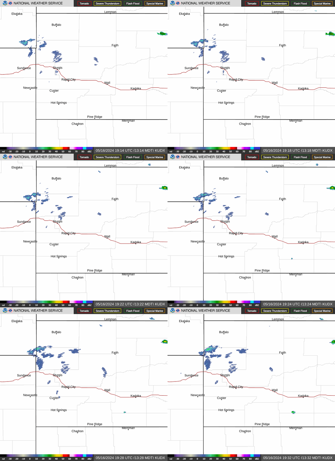
Radar — KUDX

Radar loop for KUDX

Surface Analysis — Central U.S. (North)
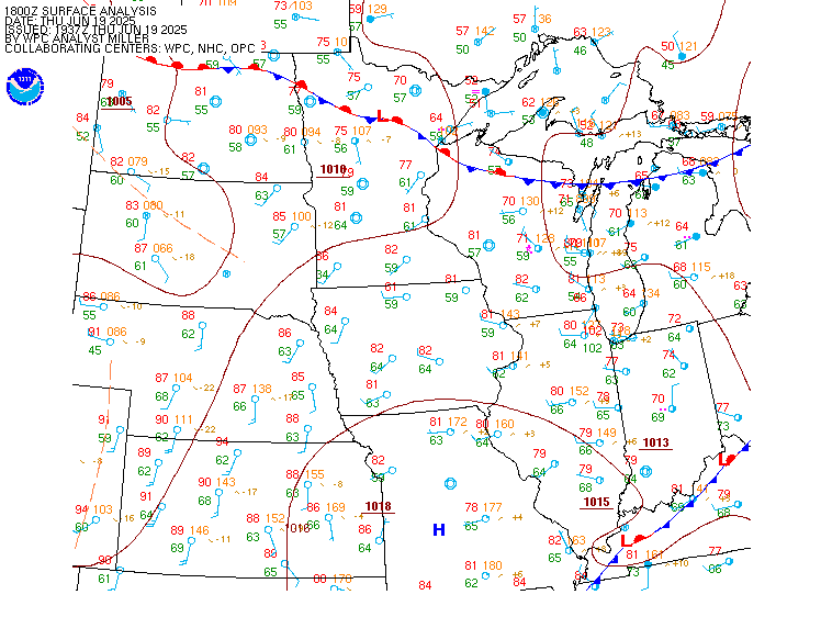
Surface map for Central U.S. (North)

Satellite

Satellite imagery
Expanded view