Radar — KLGX

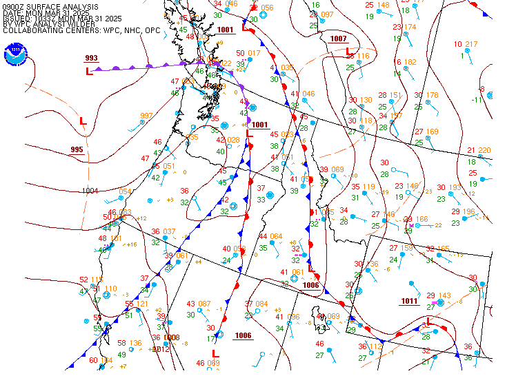
Surface Analysis — Western U.S. (North)
Satellite

Log in to save this location.
Nearest monitored road: 4th Avenue West (Primary)
Drier conditions will settle into the region into monday as an upper low moves south and a ridge builds into the region. The first half of next week will remain mostly dry, with chances of precipitation increasing mid to late week as a series of systems approaches the pacific northwest.
An upper level low will continue to weaken as it moves onshore to the south, with split flow briefly developing aloft over western washington. Cool overnight lows in the 30S will bring areas of additional frost development to the area on sunday morning while moisture in the low levels promotes another round of morning fog. A dense fog advisory has been issued for portions of puget sound and the southwest interior due to the expected fog development. Fog is already beginning to develop in isolated river valleys, and is expected to further expand tonight into sunday morning.
High pressure building into the pacific northwest will maintain dry conditions and seasonable temperatures through monday, with periods of morning fog and afternoon sun breaks. As the upper level ridge axis shifts eastward on monday, ensembles continue to show low chances of rain generally along the coast and over the olympic peninsula.
Chances for light rain continue into tuesday as a splitting frontal system passes over the region. Wetter and more unsettled conditions are expected to return on wednesday and beyond as a series of systems are set to move over the region. While ensembles continue to show a fair amount of variability heading into next weekend, the system friday looks to be the strongest and will likely bring breezy winds alongside widespread lowland rain and mountain snow.
Jd/15
Most locations across western washington are VFR this evening. Areas of localized fog have begun to form around olympia and the in the middle chehalis river valley and will continue to expand and encompass much of the western wa lowlands. The highest confidence remains across the metro area south of everett, through will also expand, at least briefly, towards hqm and bli. This will bring widespread LIFR conditions through sunday morning. Improvement to VFR expected after 18-20Z. Northerly surface winds 4-6 KT becoming light and variable tonight into sunday morning.
Ksea...VFR conditions today. Conditions will deteriorate sunday morning with LIFR fog expected to form at the terminal after 10Z- 12Z, through latest satellite trends indicate the potential for an earlier start. Conditions will improve to VFR after 18-20Z. NW winds will ease this evening becoming 5 KT or less into sunday morning.
29/62
Shower activity was decreased this afternoon across the coastal waters and the threat for brief waterspouts has ended.
A surface low pressure will continue to dig south today. High pressure will build over the waters tomorrow through monday. A system will approach the coastal waters to the north, leading to an increase in winds over the outer coastal waters on monday. Latest guidance suggests there is a 55-70% chance for wind gusts briefly exceeding 21 KT monday morning over zones pzz170 and pzz173. High pressure will move inland on tuesday. The next system arrives wednesday. Winds will increase across the coastal waters; however, latest probabilities indicate a 40-50% chance for wind gusts meeting small craft thresholds. A stronger system will impact the waters thursday into friday, bringing stronger winds across the coastal waters and interior waters, with latest probabilities at 65-75% for winds above 21 KT.
Seas 4-6 feet this afternoon, decreasing below 5 feet tonight. Seas will build on monday 7-10 feet and will hover around this range through late in the week. With the stronger system arriving friday, latest guidance suggests seas will build up to 13-16 feet.
29