Weather Lookup

⚠ Active Alerts

Coastal Flood Advisory Coastal Flood Advisory issued July 28 at 9:09PM PDT until August 1 at 3:00AM PDT by NWS San Diego CA
High Surf Advisory High Surf Advisory issued July 28 at 9:09PM PDT until August 1 at 5:00PM PDT by NWS San Diego CA
Beach Hazards Statement Beach Hazards Statement issued July 28 at 9:09PM PDT until July 29 at 5:00PM PDT by NWS San Diego CA
Heat Advisory Heat Advisory issued July 28 at 9:01PM PDT until August 2 at 8:00PM PDT by NWS San Diego CA

Current Conditions — KSAN

70°F Cloudy
💧 Humidity 83%
💨 Wind 7 mph S
👁 Visibility 10.0 mi
🌡 Pressure 29.9 inHg

Hourly Forecast — San Diego,CA

11:00 PM 69°F Mostly Cloudy 💨 5 mph S
12:00 AM 68°F Mostly Cloudy 💨 5 mph S
1:00 AM 68°F Mostly Cloudy 💨 0 mph
2:00 AM 68°F Mostly Cloudy 💨 0 mph
3:00 AM 68°F Mostly Cloudy 💨 0 mph
4:00 AM 68°F Mostly Cloudy 💨 0 mph
5:00 AM 68°F Mostly Cloudy 💨 0 mph
6:00 AM 67°F Mostly Cloudy 💨 0 mph
7:00 AM 68°F Mostly Cloudy 💨 0 mph
8:00 AM 69°F Partly Sunny 💨 0 mph
9:00 AM 72°F Partly Sunny 💨 5 mph S
10:00 AM 75°F Partly Sunny 💨 5 mph SW
11:00 AM 77°F Sunny 💨 5 mph SW
12:00 PM 78°F Sunny 💨 5 mph SW
1:00 PM 78°F Sunny 💨 10 mph SW
2:00 PM 79°F Sunny 💨 10 mph SW
3:00 PM 79°F Sunny 💨 10 mph SW
4:00 PM 78°F Sunny 💨 10 mph SW
5:00 PM 77°F Partly Sunny 💨 5 mph SW
6:00 PM 76°F Mostly Cloudy 💨 5 mph SW
7:00 PM 73°F Mostly Cloudy 💨 5 mph SW
8:00 PM 70°F Mostly Cloudy 💨 5 mph SW
9:00 PM 69°F Mostly Cloudy 💨 5 mph SW
10:00 PM 69°F Mostly Cloudy 💨 5 mph SW

Daily Forecast — San Diego,CA

Tonight 67°F Mostly Cloudy 💨 0 to 5 mph S
Wednesday 79°F Mostly Sunny 💨 0 to 10 mph SW
Wednesday Night 67°F Mostly Cloudy 💨 0 to 5 mph S
Thursday 80°F Mostly Sunny 💨 0 to 10 mph W
Thursday Night 68°F Partly Cloudy 💨 0 to 5 mph W
Friday 82°F Mostly Sunny 💨 0 to 10 mph NW
Friday Night 71°F Partly Cloudy 💨 0 to 5 mph W
Saturday 85°F Mostly Sunny 💨 0 to 10 mph NW
Saturday Night 71°F Partly Cloudy 💨 0 to 5 mph W
Sunday 83°F Mostly Sunny 💨 0 to 10 mph W
Sunday Night 69°F Partly Cloudy 💨 0 to 5 mph SW
Monday 80°F Mostly Sunny 💨 0 to 10 mph SW
Monday Night 68°F Partly Cloudy 💨 0 to 5 mph W
Tuesday 79°F Mostly Sunny 💨 0 to 5 mph W

🚗 Road Conditions

Good

Nearest monitored road: West Broadway (Secondary)

12:45 AM Good
1:00 AM Good
1:15 AM Good
1:30 AM Good
1:45 AM Good
2:00 AM Good
3:00 AM Good
4:00 AM Good

Forecast Discussion — SGX

View Full Discussion on NOAA →

Synopsis

Near to slightly above average temperatures will only last through wednesday before another heatwave begins. High pressure to the east is expected to strengthen and move westward late this week, bringing a return of moderate to major heatrisk for thursday onward into early next week. Temperatures peak saturday and sunday with some record highs expected in the mountains and deserts along with locally extreme heatrisk. The marine layer and associated morning clouds will become more shallow and confined to coastal areas by late this week.

Discussion

For extreme southwestern california including orange... San diego...western riverside and southwestern san bernardino counties...

..


Updated Aviation Discussion

The main story this week is the incoming heatwave beginning on thursday. An upper ridge currently located to the east will strengthen and move westward through this weekend. There is strong agreement among models that 500 mb heights will peak somewhere around 597 to 600 dm on saturday, setting the stage for the hottest temperatures of the year so far for inland areas. High temperatures ranging from a few to 8 degrees above normal on thursday will combine with slightly above normal lows to create moderate to locally major heatrisk for inland areas. By the weekend, both high and low temperatures increase to 5 to 12 degrees above normal. Peak temperatures this weekend will range from the 80S in coastal areas to 115 to 120 in the low deserts. 90S expected in the western valleys and mountains below 7000 feet, low 100S in eastern san diego valleys, and 100S to near 110 in the inland empire and high desert. This will create moderate heatrisk for coastal areas, moderate to major heatrisk for inland valleys and mountains, and major to extreme heatrisk in the deserts. Some daily record highs are expected to fall in the mountains and deserts this weekend.

As a consequence of the building upper ridge, the marine layer is expected to become more shallow and confined to coastal areas by late week. Minor visibility reductions will become possible for coastal areas each morning this weekend. Additionally, increasing inversion strength may allow for marine layer clouds to persist into the afternoon along the immediate coastline. This adds uncertainty to current high temperature forecasts. Current highs are expected to range 5 to 10 degrees above normal (generally low 80S) along the coastline this weekend. If clouds are present in the afternoons, highs will be closer to seasonal averages.

The ridge is expected to weaken early next week, bringing a slight cooling trend. However, high temperatures are generally expected to remain above average. Thus, moderate heatrisk will likely continue for inland valleys/mountains with major heatrisk in the deserts. Model guidance diverges more significantly from mid-next week onward, though there is some indication that a more favorable monsoon pattern will re-emerge.

Aviation

290600Z....coast/valleys...low clouds based 900-1200ft msl are moving inland and will continue to spread northward through 14Z. Slight chance (20%) of cigs at kont intermittently between 12Z and 16Z. Vis 3-5sm where stratus nears higher coastal terrain and in the western valleys. Low clouds clearing to the coast 16-18Z, with stratus potentially lingering at beaches through the afternoon. Low clouds redevelop around 00Z thur, moving inland by 01-03Z with similar or slightly lower bases.

Mountains/deserts...mostly skc with unrestricted vis through wednesday. Intermittent high cu aoa 20,000ft possible.

Marine

No hazardous marine weather is expected through sunday.

Beaches

A south swell from 200 degrees of 3-4 ft feet at 17 seconds will produce surf of 3-6 feet with sets to 7 feet wednesday. Strong rip currents are expected along with minor tidal overflow during the evening high tide.

Wednesday evening, a 4-5 ft swell from 160-180 degrees with a period of 13-15 seconds associated with hurricane genevieve will arrive. Surf of 5-9 ft is expected on south facing beaches in orange county with surf around 3-6 ft elsewhere. Surf will peak on thursday and friday, when the swell direction shifts to 180-190 degrees. Strong rip and longshore currents will create dangerous swimming conditions at most area beaches. In addition to the high surf, evening high tides will be above 6 ft this week. The combination of high tides and surf increases the risk of coastal flooding. The swell, period, and tides are expected to decrease over the weekend. Further information can be found in the high surf advisory.

Radar — KNKX

Radar loop for KNKX

Surface Analysis — Western U.S. (South)
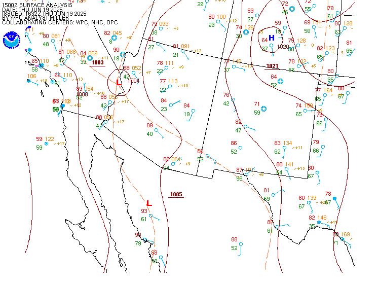
Surface map for Western U.S. (South)

Satellite

Satellite imagery
Expanded view